Página inicial
PLUS
Ferramentas de geração de IA
Novo
Gerador de imagens AI
Entregando criatividade à sua imaginação.
Novo
Upscaler de imagem AI
Amplie suas imagens em até 4x com um clique!
Novo
Preenchimento generativo de IA
Remova e substitua objetos em segundos!
Novo
Desfoque de Fundo com IA
Desfocar os fundos para destacar os objetos!
AI Background Remix
Fundos profissionais para seus produtos.
AI Image Extender
Amplie suas imagens para diferentes proporções.
Escrita de IA
O melhor companheiro de escrita para a era digital.
Remoção de fundo de IA
Remova facilmente fundos indesejados.
123RF PLUS
Obtenha soluções criativas com o auxílio de ferramentas de IA de ponta.
Ir para o PLUS
Temos duas novas ferramentas de IA!
Confira agora o Upscaler de imagem AI e o Preenchimento generativo de IA!
OK
Imagens Gratuitas
Stock
Fotos
Vetores
Vídeos
Áudios
Fontes
Corporate+
Preços
Ajuda
br
English
Deutsch
Español
Français
Magyar
Italiano
日本語
한국어
Nederland
Język polski
Português (PT)
Português (BR)
Русский язык
简体中文
繁體中文
Türkçe
Login
Vá ilimitado
Pesquisa por imagem
Pesquise no 123RF com uma imagem em vez de texto. Tente arrastar uma imagem para a caixa de pesquisa.
Arraste e solte o arquivo ou
Navegar
Arraste a imagem aqui
Todas as Imagens
Opções
Pesquisa por imagem
PREMIUM
Todas as Imagens
Fotos
Vetores
Vídeos
Áudios
Fontes
FREE
PLUS
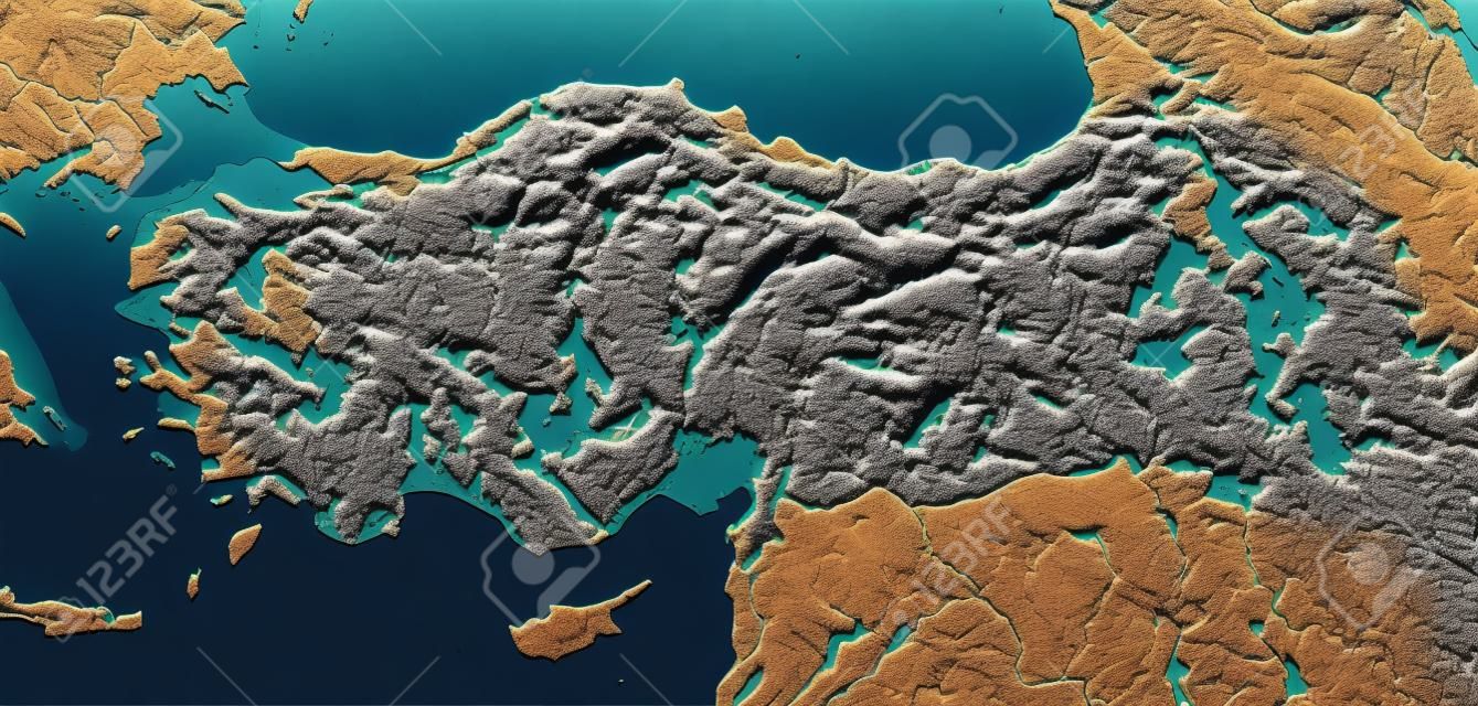
Turkey. Shaded relief map with major urban areas. Surrounding territory greyed out. Colored according to elevation. Includes clip path for the state area. Projection: Mercator Extents: -75/-58/-1/14 Data source: NASA
AI Variation
AI Variation
mschmeling
Siga
Pré-visualização
Compartilhar
X
Facebook
Pinterest
11687665
Foto PLUS
Pesquisas de banco de imagens
turkey physical map
turkey map
physical
istanbul
atlas
ankara
balkan
dardanelles
3d
topography
asia
shaded
aegean
relief
bosporus
turkish
mediterranean
topographic
terrain
nasa
europe
bathymetry
earth
chart
turkey
anatolia
hellespont
map
geography
Imagens de estoque semelhantes


 Pinterest
 11687665

 Novo
Novo
 Novo
Novo
 Novo
Novo


